
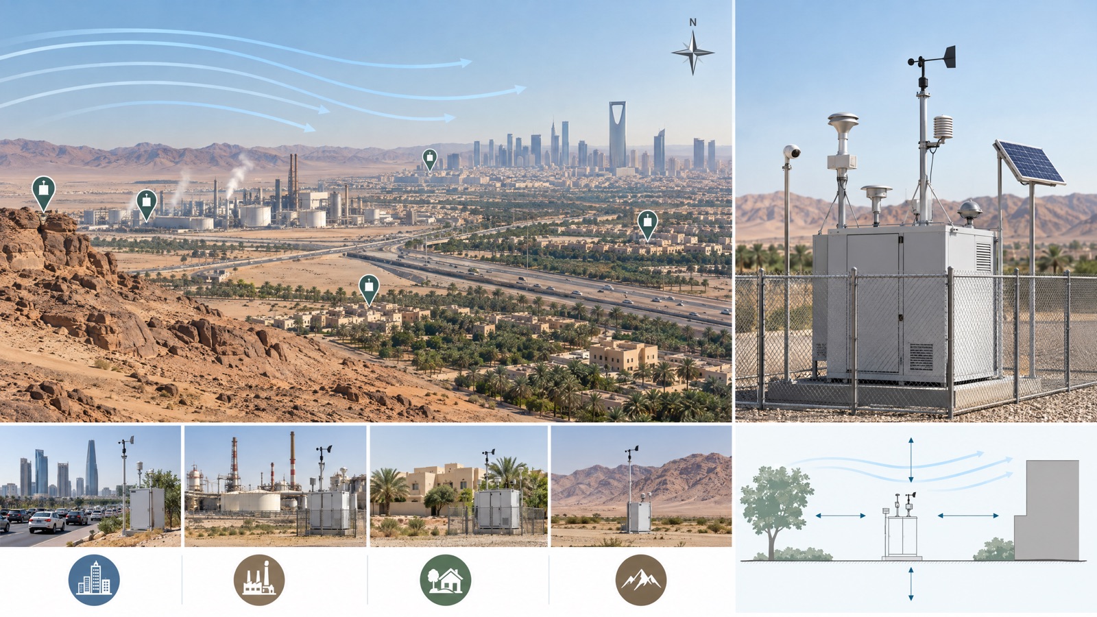
This guide explains how to design an air quality monitoring network in Saudi Arabia, helping project teams define objectives, station locations and data requirements before they buy equipment. An ambient air-quality network should begin with decisions, not a shopping list: before choosing stations, a Saudi project team needs to agree what the network must reveal, which locations represent each question, what data quality is required and who will act on the results.
You receive a written proposal setting out the configuration, scope, lead time and price. Request a quotation
This guide provides a practical pre-procurement framework. Equipment supply and this guide do not replace the permit, approved method or regulatory decision that applies to your project, such as a formal baseline-study design or a regulator-approved monitoring plan.
1. Write the monitoring objective first
A broad aim such as “measure air quality” is difficult to design against. Replace it with specific questions. Does the owner need to understand incoming background conditions, changes near a project boundary, community context, construction dust, traffic influence or operating trends? Is the data intended for operational awareness, investigation, stakeholder communication or a prescribed submission? Each purpose can require different instruments, siting and quality controls.
Create an objective register with the decision, parameter, time resolution, quality expectation, responsible user and planned response. Keep regulatory and non-regulatory uses separate. The US Environmental Protection Agency’s Air Sensor Toolbox notes that lower-cost and portable sensors differ from regulatory-grade monitors and provides guidance on study design, performance and interpretation. That guidance is useful, but the applicable Saudi specification remains controlling.
2. Give every location a role
A proposed station should answer a stated question. Possible roles include:
- an upwind or incoming-condition point
- a downwind or boundary location
- a background or context location
- a community-facing point
- a roadside location
- a source-oriented investigation point
One site may serve more than one role only when the siting evidence supports it.
Plot sources, receptors, terrain, buildings, roads and prevailing wind sectors before fixing locations. Then test inlet height, airflow obstruction, nearby exhausts, security, access, power, communications and safe maintenance. A convenient wall or outlet is not automatically representative. Network design and instrument siting can turn these questions into a location schedule.
3. Match pollutants and station classes to the questions
Build the pollutant list from relevant sources and receptors rather than copying a generic package. Depending on the objective, candidates might include particulate fractions, nitrogen dioxide, sulfur dioxide, ozone, carbon monoxide, hydrogen sulfide, volatile-organic-compound indicators or meteorological parameters. Expected concentrations, averaging needs and possible interferences influence the method and range.
A mixed network can be more useful than identical stations everywhere. Compact nodes may extend coverage, while higher-assurance stations can perform comparison, broader measurement or critical-location roles. The specification should state what evidence is acceptable for each intended use.
Weather data can be essential when interpreting direction and transport. Wind speed and direction, temperature, humidity, pressure or rainfall may be relevant, but sensors need suitable exposure and time alignment. See meteorological and air-quality integration for that separate design layer.
4. Plan quality assurance and collocation
The quality plan should exist before data starts. It can define:
- incoming inspection and configuration control
- time and unit conventions
- zero and span checks where appropriate, flow and inlet checks, and calibration
- preventive maintenance, data completeness, fault flags and review rules
- audit trails and corrective action
Requirements should be proportionate to the data use and instrument class.
The EPA’s air-sensor collocation guide explains how operating an air sensor alongside a reference monitor can help evaluate accuracy. Collocation may inform bias, variability and environmental response, but it does not convert every sensor into a reference instrument. The project should decide which devices will be compared, for how long, under which conditions and how the findings will affect configuration or interpretation.
5. Design communications and ownership
A network also needs a data architecture. Define sampling and reporting intervals, local buffering, cellular or wired connections, timestamps, device status, retention, dashboard users, alarms and exports. Decide what happens during a power or communications outage and who supplies SIM cards, data plans, network access and cybersecurity approval. Alarm thresholds need owners, verification steps and escalation routes.
The National Center for Environmental Compliance describes its Saudi environmental-monitoring role as including oversight and follow-up across environmental media, data analysis, reports and databases. Check current NCEC and other applicable requirements directly: an equipment dashboard is operational support, and formal submissions need their own method, governance and authorisation.
6. How to design an air quality monitoring network: a procurement-ready design basis
Before requesting equipment proposals, assemble a site plan, objective register, proposed station roles, parameter and range schedule, station classes, power and communications assumptions, data requirements, quality plan, maintenance expectations and responsibility matrix. Separate mandatory requirements from preferences and ask vendors to identify deviations. This makes alternatives comparable and exposes missing civil, electrical, telecom or service scope.
When that brief is ready, move to ambient air-quality monitoring network procurement. If objectives or station classes are still uncertain, begin with a monitoring needs assessment. Network supply is available for projects across Saudi Arabia, including Dammam, Jubail and Riyadh.
Frequently asked questions
Who is the ambient air quality monitoring network supplier in Saudi Arabia?
EnviroSaudi supplies ambient air quality monitoring network equipment and design support for projects across Saudi Arabia, from the monitoring objective and location schedule through to the quotation.
How many stations does an ambient network need, and what affects the cost?
There is no reliable universal number. Station count follows the monitoring questions, source and receptor pattern, wind and terrain, instrument class, required coverage and access. Cost follows the same factors plus parameters, power, communications, quality plan and maintenance scope, so each proposed location should have a written role before quantity is fixed.
How do I design an air quality monitoring network and choose where to locate stations?
Locations may represent background, incoming wind, site boundaries, downwind conditions, communities, roads or specific sources. Final siting considers airflow, obstructions, inlet height, nearby activities, security, power, communications and safe maintenance access.
Can a network use compact air sensors?
Compact sensors can add spatial and temporal coverage when selected and evaluated for the intended use. They are not automatically equivalent to regulatory-grade monitors. Performance evaluation, collocation, maintenance and clear interpretation boundaries may be required.
Why add meteorological measurements?
Weather data can help relate concentration changes to wind direction, wind speed and atmospheric conditions. It is useful only when the instruments are correctly exposed, maintained and time-aligned with air-quality results.
How long does delivery take, and what should I prepare before asking for proposals?
Delivery time depends on station class, quantity, and civil, power and telecom readiness, and is confirmed in the quotation. Prepare the monitoring objectives, site plan, station roles, pollutants and ranges, applicable specification, power and connectivity, data and alarm needs, quality controls, maintenance model and a responsibility matrix.
Is this guide a formal Saudi baseline-study design?
No. A formal baseline, permit or compliance programme follows current Saudi requirements and a project-specific plan approved by the responsible parties.
EnviroSaudi serves projects across Saudi Arabia, including Dammam, Al Khobar, Jubail, Riyadh, Jeddah, NEOM and Qiddiya.
Once you know how to design an air quality monitoring network for your site, turn it into a station scope. Request a quotation and EnviroSaudi will set out the station scope for your project.